Here are the coordinates:
Format: Foreflight Garmin
Start Lat: 40.03816 N 40 02.290
Long: -86.25082 W
86 15.049
Turn 1 Lat:
40.17450 N
40 10.470
Long: -86.22142 W
86 13.285
Turn 2 Lat: 40.28465 N 40 17.079
Long: -86.85397 W
86 51.238
Turn 3 Lat: 39.99687 N 39 59.812
Long: -86.57864 W 86 34.718
Finish Lat: 40.03110 N
40 01.866
Long: -86.25237 W
86 15.142
Here's what it looks like in ForeFlight:

We will cover the converging point of the two courses in the brief. Both courses start the same but at the Timber House turn (Turn 2) the short course splits off in another direction. Then over Boone County Airport the paths converge.
Two screen shots for Turn 2. First, an aerial view of Turn 2 for the short course, Timber House:

Note in the next screen shot that the two courses part ways here. Short course racers make a harder left turn. Be careful not to follow someone flying the other course!

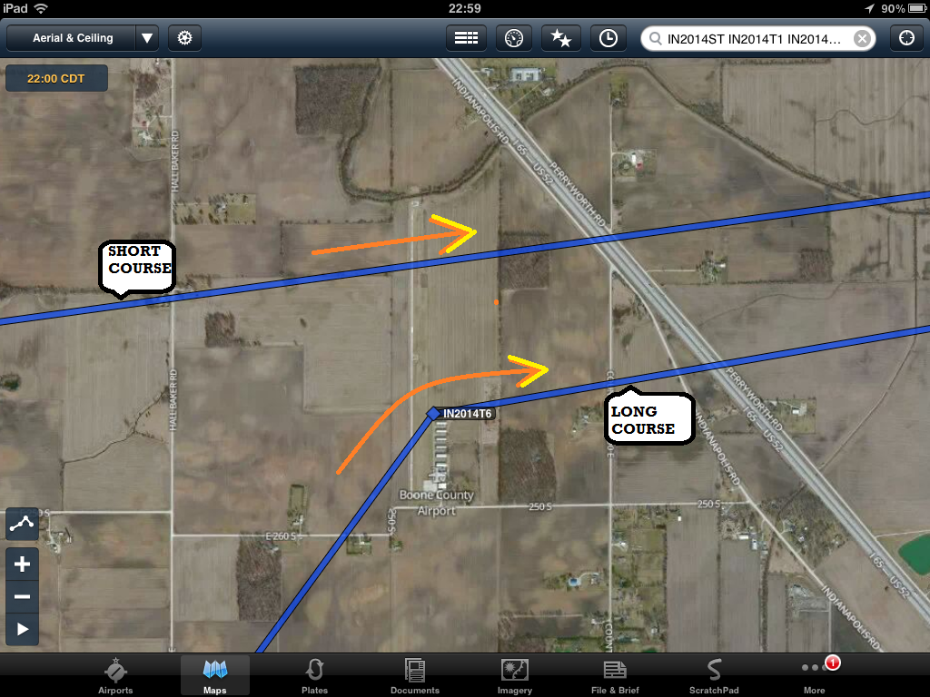
Here's an aerial view of the flight path of the short course over Boone County, which is very close to the Standard Course Turn 5: Pay attention! There are two screen shots for you.

Expect to see Standard course racers near your path over Boone County. This is not a turn point for Short course racers, but it is a turn point for Standard course racers.
Need to know how put those turn points exactly where you want them in ForeFlight? You came to the right place!
Open ForeFlight. On the bottom ribbon tap More.
Tap User Waypoints
Tap + (its in the upper right corner)
Enter a Name (such as LyonsDen), a Description (such as Turn5), and the Lat and Lon (see Coordinates page)
Tap Save (upper right corner)
Go to Maps
Pull down NavLog, (button at top of Maps page with three lines), tap Edit (lower part of the drop down)
Tap inside the box and a keyboard pops up.
Type the Name you chose for the waypoint, then space.
ForeFlight adds your waypoint at the end.
To move it where you want it just "grab" it with your finger (not a tap but a tap and hold), and slide it into the place where you want it.
The waypoint is now added to your route.
Or, in the Maps view, change the map to Aerial.
Locate the exact point where you want to create a User Waypoint and tap and hold just a second.
"Add to Route" will appear.
Tap Waypoints at the bottom of that box.
The top selection contains the coordinates of the place where you tapped.
Tap More, next to that top selection.
Tap Save.
Enter a Name (Lyons Den)
Enter a Description (Turn 5)
Tap Save.
With ForeFlight's new Track Log feature you can track your flight, save and share your race.
No comments:
Post a Comment